Back to intro or goto next section or goto dam update page
The Dams of Redridge
A stamp mill requires water for use in the "wash" of it's operations to
separate the copper mineral from the rock it was mined from. One of the
reasons the Atlantic mill was placed in Redridge was the fact that it had
a stream, the Salmon Trout River, that could be dammed up and used to
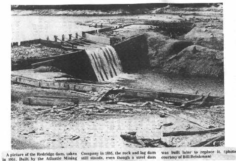
supply water for their mill. The first dam constructed on this site was a
timber crib dam built of timber, loose rock and earth. The main portion is
53 feet thick at the bottom, 28 feet thick at the top and 50 feet high.
The length across the stream is 51 feet at the bottom, 228 feet at the top.
The timbers were 14 inches thick and hewed flat, bound together with
inch square drift bolts. The upstream face was lined with four inch plank,
which was then covered in 2 inch plank. An earthen embankment was
constructed on the inner side of the dam with a slope of 1.5 to 1. When
referring to the earthworks of this dam, the word constructed is somewhat
of a misnomer. All of the work on this dam was done by hand, no heavy
construction equipment was available, so all of the dirt was literally
shoveled into place. At the base of the dam, near the east bank of the
river, there were two cast iron pipes 24 inches in diameter with gate valves
placed about 170 feet back from the toe of the dam. These gates were
then closed to allow the dam to fill. The water was transported from dam to
mill via a launder 18"X36" in cross section, 2050 feet long and dropped
5 inches per 100 feet of length.(25) The cost to Atlantic Mining Company
for the dam was a total of $24,161.58. Below is a picture of this dam
as it looked in 1951 after the steel dam had been drained.
The current picture of this dam may be seen at the top of this section.
An intriguing feature of this timber dam is the offshoot of the dam just to the west of
the main portion. It can be seen in the 1951 photo on the right side of the dam.
It took a long time for this researcher to come up with
a reason why it is there in the first place. The area behind this part of the
dam does not look like it would have held back water very often. There is a
large depression several feet behind it, but it is not currently connected to
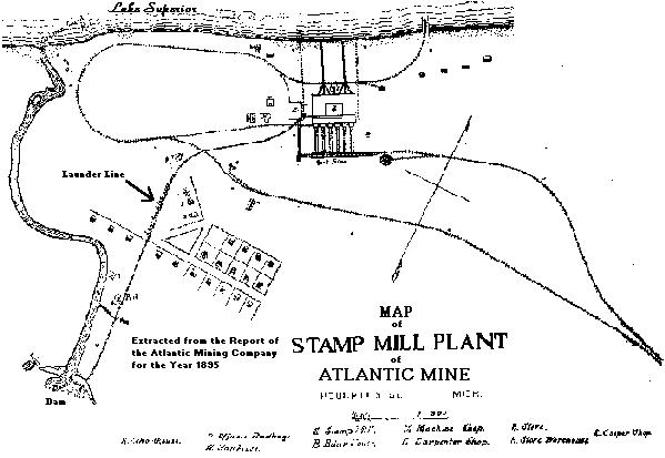
the rest of the old reservoir that the old dam still holds. The diagram of the
Atlantic site from the 1895 Atlantic stockholder report
shows water behind this portion, though it is possible that this area was filled in somehow during
construction of the new dam or by deposits while it was submerged behind
the new dam. The answer comes when one looks at the 1951 picture,
and then at the Redridge site plan. The small channel that this
downstream of this portion is angled in such a way to suggest that it is where the small creek
coming from the west emptied into the Salmon Trout River.
Reports from the Atlantic Mining Company in 1900 stated that the crib
dam was showing signs of weakening(26) and since Baltic Mining Company
was in the process of building it's own stamp mill at the site, a new larger
dam was to be constructed so both mills would have enough water to operate.
Horace Stevens in the Copper Handbook of 1900 "The peculiar conditions
prevailing at the mouth of the Salmon Trout rendered a dam of ordinary pattern
almost out of the question."(27) They were peculiar in that there were no
nearby sources of stone for a masonry dam, and the site was far too remote
to haul in the materials necessary to build a regular dam. Also,
copper prices had boomed in the years since Atlantic Mine first built their mill,
so the companies could not wait for a conventional dam, especially with such
short construction seasons that are typical to the area. Atlantic and Baltic mills
needed something fast, and so they decided to try a new technology, steel dams.
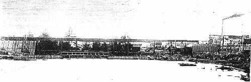
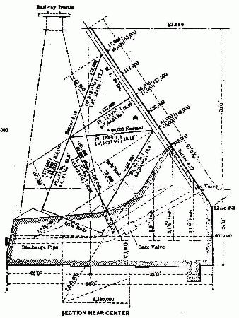
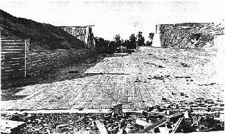
The photo above shows the dam in early phases of construction.(28) The steel portion of this dam is 464 feet
long(29) and at it's central portion is 74 feet tall. The steel portion of the dam is
flanked by concrete core earthen embankments on each end to stretch the total
length of the dam to 1006 feet. Water was taken from the dam through three
valves near the ends of the steel structure 20 feet below the crest. Sources of
information on this feature of the dam vary somewhat as to what dimensions these
were. Company reports do not mention it, Copper Handbook lists 38 inch diameter
pipes, Engineering News listed 24" valves(30).
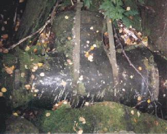
Personal 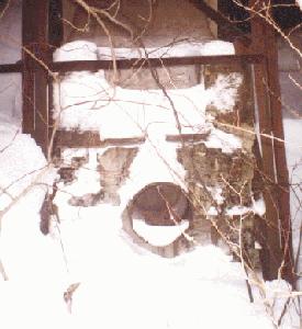 examination of the remains
of the Atlantic feed (photo at right) shows that this particular pipe is 24" in diameter.
The size
of the pipe leading down to the Baltic is also contradicted by the Sanborn maps of
that facility, which list one 36" diameter pipe leading into the mill instead of a 38"
pipe reported in the other sources. In the original writing of this report, I was unable to
measure the baltic pipes because they were buried in snow. But on a trip back there in
October 1997 I was able to take the photo below. What I found was a diameter changing
fitting with a cleanout in the middle. The left side of the fitting measured 24", and the right side
measured 38" (both outside diameters)(31)
examination of the remains
of the Atlantic feed (photo at right) shows that this particular pipe is 24" in diameter.
The size
of the pipe leading down to the Baltic is also contradicted by the Sanborn maps of
that facility, which list one 36" diameter pipe leading into the mill instead of a 38"
pipe reported in the other sources. In the original writing of this report, I was unable to
measure the baltic pipes because they were buried in snow. But on a trip back there in
October 1997 I was able to take the photo below. What I found was a diameter changing
fitting with a cleanout in the middle. The left side of the fitting measured 24", and the right side
measured 38" (both outside diameters)(31)
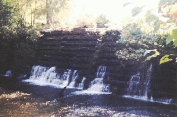
The steel dam, remarkable as it is, has features that separated it from the other
dams of it's type. For one, the dam was designed with a substantial concrete base
and a large angle from horizontal, depending on it's own weight and the weight of
the water to hold it in place. Also, unlike the other steel dams built, this one was
not built as a weir, or overflow dam, but instead used a spillway to deal with excess.
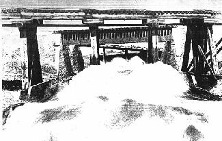
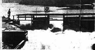
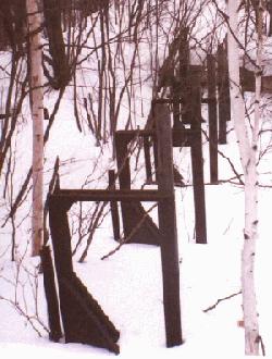
Here is a series of photos of this spillway.
weir1.jpg - The spillway nearing completion
weir2.jpg - The spillway during spring flooding in 1942.
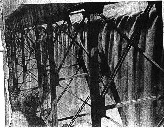
The trestles shown starting from foreground are 1. to steel dam, 2. to Baltic Stamp mill (only one still
in existance), 3. overpass for roadway to Freda, 4. railroad trestle to mill along shore.
weir3.jpg - The gates to the spillway during a spring flood. As you
can see, water has already destroyed two of the wood sections.
gates1.jpg - The gate supports as they look present day. The
panels between them were removed in 1966.
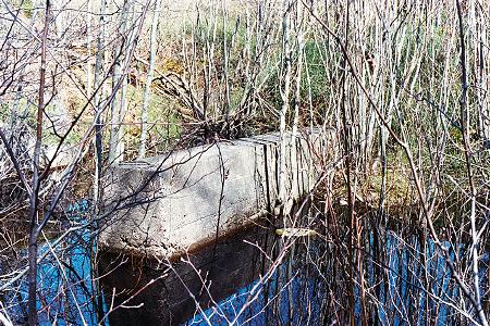
NEW! bridgepilinginweir.jpg - Shot in early May 2002, this concrete pier is one of the supports for the trestles that crossed over the weir.
This spillway was 400
to 600 feet long (depending on which source you look at), 30 feet wide, 4 feet deep,
and 6 feet below the top level of the dam. This spillway was wrecked in the spring of
1905 and had to be completely rebuilt. A major question this author had when
researching the dam is why was the spillway built in the first place? The other two
steel dams built in that period were both overflow dams with no spillway. Unfortunately
no real information on this could be found, as the records from the firm that designed
the dam had either been lost or destroyed.(32) One guess would be that since the town
was directly downstream, the sound of water crashing down from 74 feet up would not
be welcome for any prolonged period. William Brinkman, in an article in the Daily Mining
Gazette, reported that when the dam overflowed in the spring of 1941 the roar could be
heard from his home in the village.(33) This may not be the case though, as photos of
the Hauser Dam in Montana (an overflow steel dam) show what appear to be dwellings
on one bank of the river.(34) Another
guess might be that although the engineers
designed it strong enough to survive overtopping, they did not want to risk it with such a
new dam technology. The risk would be that since this dam had a larger angle than the
other steel dams, the water would be falling much closer to the foundations, risking serious
undermining. The overtopping incident in 1941 came close to wiping out the road below the dam and convinced the
owners of the dam in 1943 to open the discharge valves at the foot of the dam as much as
possible. Other attempts were made in the 50's to open them further, but the valves had
been too rusted and jammed with debris. Even with the discharge valves open, the dam
again approached flood stage in the spring of 1976, this time it did not overflow, but the
trestles over the spillway were in serious danger of collapse, which would have torn the
road apart when the debris hit it. By 1979 the Copper Range Company, owners of the dam,
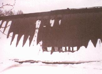
feared that the disrepair of the spillway would lead to a dam collapse. To eliminate the
possibility of that happening, the company cut 4 4' X 8' openings in the steel work just
above the concrete base. These holes can be seen in the photo at the beginning of this section.
Despite having little care since the mills it supplied water to closed down, the dam itself
is in rather good condition, but cutting the holes in the dam exposed the concrete below to
extremely harsh conditions 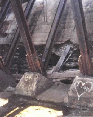 (water rapidly rushes over this area during spring thaw) and much
of the facing concrete there has crumbled away (photo at right). The dam has not had a use in over 70 years,
and yet it still stands as a testament to engineering know how in the early part of this century.
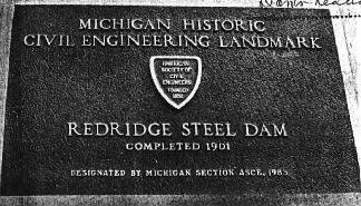
In 1985 a plaque was placed at the site listing it as a civil engineering landmark by the
Michigan section of the American Society of Civil Engineers (photo below).
(water rapidly rushes over this area during spring thaw) and much
of the facing concrete there has crumbled away (photo at right). The dam has not had a use in over 70 years,
and yet it still stands as a testament to engineering know how in the early part of this century.
In 1985 a plaque was placed at the site listing it as a civil engineering landmark by the
Michigan section of the American Society of Civil Engineers (photo below).
UPDATE: In May of 2002 I made another trip to Redridge to take photos. I felt I had to after reading on copperrange.org that the timber dam is in serious danger of being lost to us. To access the photos and commentary please click here.
This page hosted by  Get your own Free Home Page