This final chapter deals with how the area now known as Redridge changed in size and shape over the years. One change that took place was a change in name. The area was first known as Salmon Trout after the river that ran through it. Sometime between 1898 and 1910 the name was changed to it's current one.
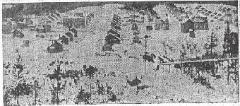
The residential area and all of the shops were built by the mining companies that owned the land. Records indicate that Atlantic Mining Company built 23 homes of various sizes from 1894-1898, along with a store warehouse, schoolhouse, barn, and the superintendent's house. The photo at the top of this section shows what the town looked like at this time. From 1899-1910, Atlantic put up 6 frame houses and an unspecified number of dwellings, a boarding house, an ice house, doctor's office, new barn and a new store.(35)
On the Baltic contribution to the community, from 1899 to 1902 they built
15 two story frame houses, 4 log houses, a schoolhouse which is still in
existance today, and 7 double log houses.(36)
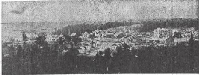
In 1912 the population of
this company town reached around 1100, with most of them living in the
central town area. Below is a photo from 1910. The large building top left in the photo is the schoolhouse
which was built in 1908 and still stands today.
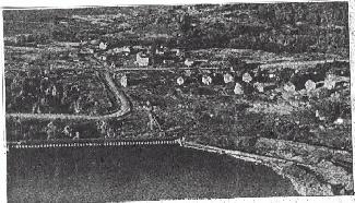
When the Baltic mill left the area the town began to shrink rather quickly.
The photo below shows an aerial view of the area in 1950, only about 15 dwellings
can be seen in this photo, the rest are empty lots.
A better photo demonstrating this decline is below, This is an aerial
view taken in 1947. One can clearly see the cellar holes from probably dozens
of homes. This photo also documents the changes that
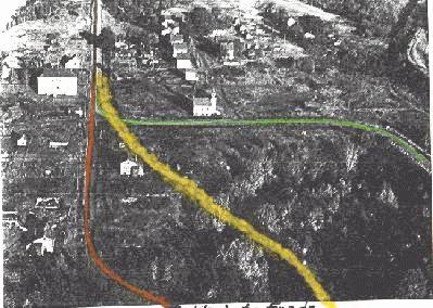 occurred to the road
running through Redridge. The path marked in red was the first road through
built in 1892. At first this road had no bridge over the river, people had to portage
across it. A bridge made of wood was built on this road in 1895-96 to accommodate
horse and buggies. The road was closed in 1919 and a new one (the one marked
in green) replaced it. This road was built by pumping water from the dam into a
huge earth and sand bank and the resulting mud flowed down launders into the
ravine, where pipes had been placed to allow the river to flow underneath the
roadway. The current road (marked with yellow) was completed in 1980 for a cost
of around $480,000.(37) Since this road was built after the Copper Range Company
had cut holes in the dam, the contractors simply covered over the part of the spillway
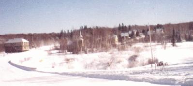
that was in the path of the road. The present road and remaining houses may be seen
in the photo at the end of this chapter.
occurred to the road
running through Redridge. The path marked in red was the first road through
built in 1892. At first this road had no bridge over the river, people had to portage
across it. A bridge made of wood was built on this road in 1895-96 to accommodate
horse and buggies. The road was closed in 1919 and a new one (the one marked
in green) replaced it. This road was built by pumping water from the dam into a
huge earth and sand bank and the resulting mud flowed down launders into the
ravine, where pipes had been placed to allow the river to flow underneath the
roadway. The current road (marked with yellow) was completed in 1980 for a cost
of around $480,000.(37) Since this road was built after the Copper Range Company
had cut holes in the dam, the contractors simply covered over the part of the spillway
that was in the path of the road. The present road and remaining houses may be seen
in the photo at the end of this chapter.
And that is the conclusion of this tour back in the history of a small Michigan town.
One that like so many others that flourished during the copper boom, faded away into
the landscape when the copper barons moved on to other things.