Go back to chapter on Baltic Mill
Take a virtual tour of these ruins! Click on the cameras inside the map to see photos taken from those
locations.(the cameras will open new browser windows, close those windows when you are done with them)
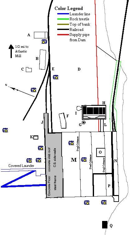 What the letters mean:
- A - Warehouse
- B - Blacksmith & Carpenter Shop
- C - Storage
- D - Coal Piles site
- E - Atlantic & Lake Superior R.R.
- F - Old Loading House (Iron Clad, vacant)
- G - 210' Concrete stack
- H - Boiler house
- I - Iron Coal Pocket
- J - Scale House
- K - Storage
- L - Passageway (Iron Clad)
- M - Stamp mill main building
- N - Rock Bins (Plank Bins in steel frame.)
- O - 150hp Dynamo
- P - Steam Turbine & dynamo
- Q - Transformer House
Note: I have 2 Sanborn maps of this site dated 1928. One of them does not depict building F or the launders
and the other one does. Also, the one missing building F includes the line "All buildings removed" in it's property description. In all
other aspects, both maps appear identical.
Description taken from Sanborn Map:
Not in operation. Watchman. clock. Heat: steam. Lights: electric. L.E.P.. Power: steam & electric. Fuel: coal.
Hydrants & hose as shown connected to Gardner Duplex Pump size
8"x5"x10". I. Fairbanks Morse FP size 12"x6"x12". I. Cameron centrifugal F.R. Capacity 200 gallons per
minute. Water supply from dam fed by Salmon Trout River. Hose cart with 800'x2 1/2" hose on location.
Note to reader
The text information cannot be guaranteed accurate at this time. The photocopy I have been working
off of is not very good. My next visit to the Keeweenaw will include a visit to the MTU Archives where
I will attempt to clarify things.
This page hosted by  Get your own Free Home Page